
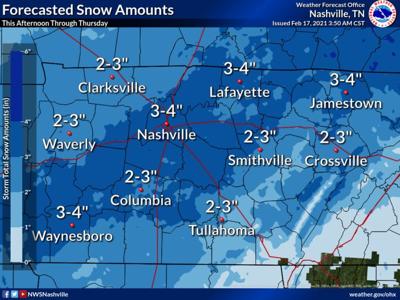

A new winter storm warning has been issued for all of Middle Tennessee, with this latest round of severe weather expected to bring 3-4 inches of snow to Williamson County starting Wednesday afternoon and throughout much of Thursday.
According to NWS Nashville, light accumulations of freezing rain are also possible, which (if you’ve looked out a window this week) will only compound on the already frozen grounds that in some places like Brentwood have seen half an inch of ice build up since Sunday.
“Most of Middle Tennessee remains covered in ice and snow from the last event, so what we receive going forward will be added on to what's already there. So our travel difficulties are going to be prolonged, unfortunately,” NWS Nashville said in a social media post, adding that the temperature is expected to drop back into the teens on Thursday.
Winter weather has already caused a headache for municipalities and their public works departments, with crews in Brentwood pulling 12-hour shifts. Many are staying in hotels provided by the city so that their workers are able to continue to clear roads as many live out of the city, making traveling to and from work either extremely dangerous or downright impossible.
As previously reported, those headaches have also been true for many first responder agencies who have seen ‘unprecedented’ calls for service, many involving disabled motor vehicles or motor vehicle crashes, as well as slips and falls.
Check with NWS for up-to-date forecasts and weather warnings.